
Across the United States, headlines about global tensions and geopolitical crises often prompt difficult questions: what if a large‑scale war ever escalated into direct conflict involving nuclear weapons?
While there is currently no confirmed global war underway, defense analysts, institutions, and scientists have long conducted scenario modeling to better understand how geography, military infrastructure.
Weather systems, and human settlement patterns could influence outcomes in extreme or worst‑case scenarios.
These studies are not predictions, but rather scientific and policy‑level exercises designed to help policymakers and emergency planners grapple with potential risks and prepare accordingly.
Understanding these analyses requires separating fact from fear — and recognizing what modeling can and cannot tell us about national risk in scenarios that many leaders and expert panels emphasize are to be prevented at all costs.

Strategic Military Assets and Why They Matter in Hypothetical Conflict
One major factor often examined in preparedness simulations is the location of strategic military assets, especially intercontinental ballistic missile (ICBM) silos and associated launch control facilities.
These installations are part of the United States’ nuclear triad — the combination of land‑based missiles, submarine‑launched ballistic missiles, and strategic bombers intended to provide deterrence against nuclear attacks.
Because ICBM silos are fixed, widely known, and geographically concentrated, they are frequently cited in simulations as hypothetical targets in a large‑scale nuclear exchange. That does not mean they are being targeted in reality; it simply reflects their importance in strategic planning.
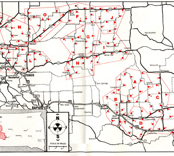
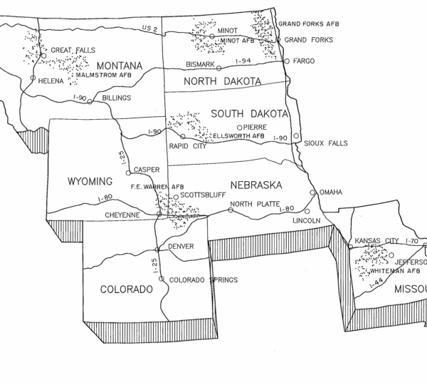
According to research from the Princeton Program on Science and Global Security and the Brown Institute for Media Innovation, the United States maintains hundreds of ICBMs housed in underground silos across five states: Montana, North Dakota, Wyoming, Nebraska, and Colorado.
Of roughly 450 silos in total, approximately 400 are believed to be armed with nuclear missiles as part of the U.S. force structure.
Because these facilities are fixed and publicly documented, they form the basis for many simulations about fallout and risk in an extreme conflict scenario.
It is well understood among defense scholars that the vulnerability of missile silos is high in the sense that, being fixed and known, they would be among the first targets in a theoretical first strike designed to degrade deterrent capabilities.
This is why they are maintained on high alert by the U.S. Air Force and why the Strategic Command (STRATCOM) constantly monitors their status.
Nuclear Fallout Modeling: How Scientists Assess Risk
Multiple academic and research institutions have developed models to estimate how radioactive fallout could spread across North America if missile silos or other strategic targets were hit in a nuclear exchange.
These models use real‑world weather data, atmospheric transport codes, and computer simulations to produce average expected outcomes under varied environmental conditions.
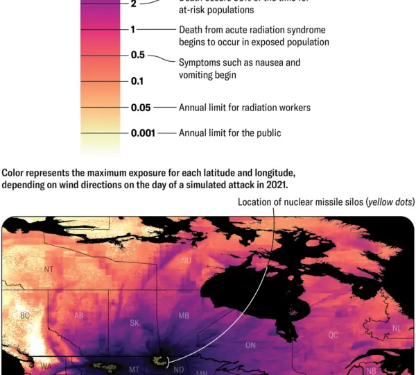
For example, the study “Under the Nuclear Cloud,” supported by researchers at Princeton University and Columbia University, uses historic wind patterns and particle transport software to assess how fallout might be distributed across populations after a coordinated attack on silo fields.
Their results show that most inhabitants of Montana, North Dakota, South Dakota, Nebraska, and Minnesota would receive average radiation doses greater than 1 gray (Gy) — a level associated with serious or lethal exposure — depending on wind and precipitation patterns.
Similarly, Scientific American published modeled fallout maps showing that, under realistic wind conditions over the course of a year, wind‑blown radioactive particles could spread well beyond initial target areas, meaning that broad regions of the country — and even Canada and Mexico — would likely be affected by fallout to some degree.
It’s crucial to emphasize that these exercises are not predictions of what will happen. They are planning tools used to estimate potential outcomes in worst‑case scenarios, highlight vulnerabilities, explore dependencies on weather and geography, and help emergency managers think through response systems.
Which U.S. Regions Are Most Often Highlighted in Modeling?
Even in hypothetical modeling, experts stress that no part of the country would be completely safe in a large‑scale nuclear conflict, and the phrase “safe” is relative — meaning “comparatively lower relative radiation exposure risk under specific assumptions.”
Areas Most Likely to Experience High Direct Risk
In many simulations, the following states are frequently cited as more directly at risk due to the presence of silo fields:
-
Montana
-
North Dakota
-
Wyoming
-
Nebraska
-
Colorado
These states host concentrations of land‑based missile silos, and simulations suggest that if these were struck, the surrounding areas could experience the highest levels of immediate radioactive fallout and blast effects.
The potential radiation exposure in these areas, according to some models, would be high enough to cause severe health effects or fatalities without adequate shelter.
The Midwest states of Minnesota, Iowa, and Kansas are also sometimes shown in modeling to receive significant fallout due to their proximity to these installations and prevailing wind patterns that carry airborne contaminants.
It’s worth noting that ICBM silo fields are clustered in parts of the Great Plains and upper Midwest not because of population or political reasons, but because these areas provided suitable land, distance from coasts, and strategic depth during the Cold War. Their locations are a legacy of decades‑old planning rather than recent geopolitical choices.
Regions Often Modeled as Lower Relative Exposure
In contrast, simulations often show lower relative estimated radiation exposure in parts of the East Coast, Southeast, and Northeast — largely due to their distance from silo fields and absence of fixed strategic missile sites. In these modeled scenarios, states occasionally ranked as comparatively lower in direct exposure risk include:
-
Maine
-
New Hampshire
-
Vermont
-
Massachusetts
-
Rhode Island
-
Connecticut
-
New York
-
New Jersey
-
Pennsylvania
-
Delaware
-
Maryland
-
Virginia
-
West Virginia
-
North Carolina
-
South Carolina
-
Georgia
-
Florida
-
Alabama
-
Mississippi
-
Tennessee
-
Kentucky
-
Ohio
-
Indiana
-
Michigan
Some simulations also show portions of the West Coast — including Washington, Oregon, and California — receiving relatively lower cumulative doses in average‑case scenarios due to distance from primary targets and wind patterns.
However, it’s important to note that even these states could be affected by fallout drift, widespread infrastructure disruption, supply chain breakdowns, contamination of water and food systems, and long‑term environmental consequences.
“Lower comparative risk” does not mean “no risk,” and every study stresses that even distant regions would be profoundly affected by a nuclear exchange of any significant scale.
Why Location Matters — And Why Geography Isn’t Deterministic
Geography plays a role in these simulations because the location of strategic targets, prevailing wind patterns, regional topography, and population distribution all influence how energy, heat, and radioactive particles might spread in a conflict scenario. But models also show that:
-
Weather and wind conditions can drastically change fallout patterns from day to day. A ‘safe’ region under one atmospheric condition could be much more affected under different weather circumstances.
-
Population centers and infrastructure hubs — including major cities, transport networks, utilities, and power grids — can become secondary targets or suffer collateral damage even if not directly hit.
-
Economic and ecological interdependence means that even regions far from initial blasts would feel systemic effects through disrupted food supplies, energy shortages, and cascading economic failures.
Indeed, defense policy specialists often emphasize that in a large‑scale nuclear exchange, even regions without direct blast or heavy fallout impacts would be altered fundamentally by the broader breakdown of normal life. The models are valuable precisely because they highlight how interconnected risk truly is.
Importantly, no serious expert predicts — or even suggests — that any specific group of states would be completely spared in the event of nuclear war. Instead, analysts point out that fallout, environmental contamination, social disruption, and economic collapse could be widespread far beyond the first strike zones.
What Preparedness Discussions Actually Focus On
Analysts, emergency planners, scholars of international security, and public health experts tend to make two key points again and again:
1. Nuclear War Is Not Inevitable
Despite periodic periods of heightened tension, countries with nuclear arsenals maintain diplomatic channels, treaties, and command‑and‑control mechanisms specifically designed to prevent escalation into direct nuclear conflict.
Arms control agreements, hotlines between heads of state, verification regimes, and strategic dialogues all function as deterrent and stabilizing measures precisely to avoid the outcomes modeled in worst‑case scenarios.
Simulations are invaluable insofar as they inform policymakers about vulnerabilities, potential humanitarian needs, and infrastructure resilience — but they are not forecasts of likely future events.
2. Preparedness Is About Resilience, Not Panic
Official preparedness guidance emphasizes resilience, risk awareness, and emergency planning — whether the risk is nuclear, natural disaster, pandemic, or cybersecurity breakdown.
Agencies like the Federal Emergency Management Agency (FEMA) advise individuals and communities to understand evacuation routes, emergency shelters, communication plans, and basic survival principles for various kinds of large‑scale emergencies.
Radiation protection, for example, is typically framed as sheltering in place or using protective barriers during nuclear fallout, steps that are part of emergency management toolkit — but also part of broader public safety education, not unique to nuclear scenarios.
The Broader Context: Preparedness Without Alarmism
It is understandable — in an era of rapid news cycles, geopolitical volatility, and emerging technologies — that members of the public might feel concerned about large‑scale conflict.
Headlines about military exercises, diplomatic disputes, nuclear posturing, or rising tensions can leave ordinary citizens wondering what would happen if the worst occurred.
However, it is essential to balance that awareness with accurate understanding:
-
Scientific and defense models about nuclear fallout are not warnings of imminent events. They are exercises in preparedness designed to inform planners and policymakers.
-
Strategic asset locations such as missile silos make certain areas more prominent in modeling, but geography itself does not create inevitability. These results depend critically on assumptions like wind, weather, conflict scale, and human decisions.
-
No part of the country is “completely safe” in the absolute sense, nor is there a consensus among experts about specific lists of ‘targets’ beyond understood strategic infrastructure. North American nuclear risk assessments generally show that fallout would spread beyond initial strike zones and affect regions far from primary targets.
Preparedness discussions in government and academia focus on infrastructure resilience, emergency response capacity, public health systems, and continuity of government in the face of catastrophic disruptions — whether caused by nuclear, environmental, technological, or biological phenomena.
Conclusion: Realism, Not Fear
The question of which parts of the United States might be most vulnerable in an unprecedented, extreme conflict scenario is a legitimate one for academic, defense, and public planners — but it must be grounded in nuanced understanding, not fear.
Strategic simulations show that areas with concentrations of fixed military assets such as missile silos are often focal points in modeling, but these exercises are not predictions and should not be interpreted as factual forecasts of future targeting.
Instead, they highlight:
-
the nature of strategic deterrence and why certain assets are located where they are,
-
how weather and geography influence hypothetical fallout patterns,
-
and why broad resilience — in healthcare, infrastructure, environment, and emergency systems — matters for any major crisis.
The overarching message from defense policy experts and scientific analysts is that the avoidance of nuclear conflict remains the paramount goal of diplomacy, deterrence, and international governance, and that preparedness is fundamentally about building systems capable of protecting communities in a wide range of plausible emergencies — not preparing for a specific predicted attack.